Tarakeswar Fm
Type Locality and Naming
OUTCROP: Named after Tarakeswar village. Outcrop in a canal section at 1.5 km south of Tarkeswar village and Well Broach-B, (2687-2833 m). 146 m thickness in Well Broach-B [Original Publication: Sudhakar, R and Basu, D.N. (1973) A reappraisal of the Paleogene stratigraphy of southern Cambay Basin: ONGC Bull., Vol. 10 (1-2), pp. 55-76.]
Reference well: Well Dahej – 1 (depth interval 581-665 m), its thickness is of 84 m.
Synonyms: The name Tarkeswar Formation has been given by Sudhakar and Roy (1959) for the outcropping sediments near Tarkeswar village. Subsequently, this formation was included in the Kathana Fm by Chandra and Chowdhary (1969) by designating type sections in a Kathana well. However, based on the priority, the name Tarkeswar Formation proposed by Sudhakar and Roy (1959) is retained by Pandey et al., 1993.
Lithology and Thickness
Sandy claystone. In the type section, lithology comprises of variegated claystone, mottled claystone, minor argillaceous sandstone and ferro-dolomitic spherules. Occasionally thin streaks of coal are also encountered. In reference section, the formation consists of alternations of variegated, soft claystone and coarse- to medium-grained sandstone. Laterally, South of Narmada the lithology is dominantly claystone with occasional bands of sandstone, while to the north of the Narmada the sandstone content increases. Thickness varies from 50-125 m.
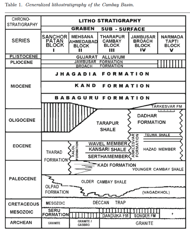
[Figure 2: Generalized stratigraphy of the Cambay Basin. (from Jaiswal and Bhattacharya, 2018, J.EarthSyst.Sci., 127:65)]
Relationships and Distribution
Lower contact
It has unconformable lower contact with the Dadar Fm (in south) and the Tarapur Fm shale (in southern-central)
Upper contact
Unconformable upper contact with the Babaguru Fm.
Regional extent
Tarkeswar Formation is met in the outcrops south of the Narmada river and occupies and extensive area in the south Cambay Basin subsurface. The formation is not considered in North Cambay Basin i.e., to the north of river Mahisagar; and this time-interval is shown as a hiatus on some regional stratigraphic charts. However, equivalent facies developed in North Cambay Basin in Cambay-Kathana area which was identified as Kathana Fm by Chandra and Chowdhary (1969) has been merged in Babaguru Fm being similar lithological homogeneity and homotaxiality by Pandey et al., 1993.
GeoJSON
Fossils
The formation is poorly fossiliferous with rare occurrence of Quinqueloculina sp., Ammonia sp., and arenaceous foraminifera, gastropods and ostracods.
Age
Depositional setting
Additional Information
